
East Nusa Tenggara governor mobilizes multi-agency response after magnitude 7.7 earthquake
Governor Emanuel Melkiades Laka Lena coordinated emergency operations across Flores following Saturday's earthquake, which struck at 10 kilometers depth and triggered over 230 aftershocks and small tsunamis.
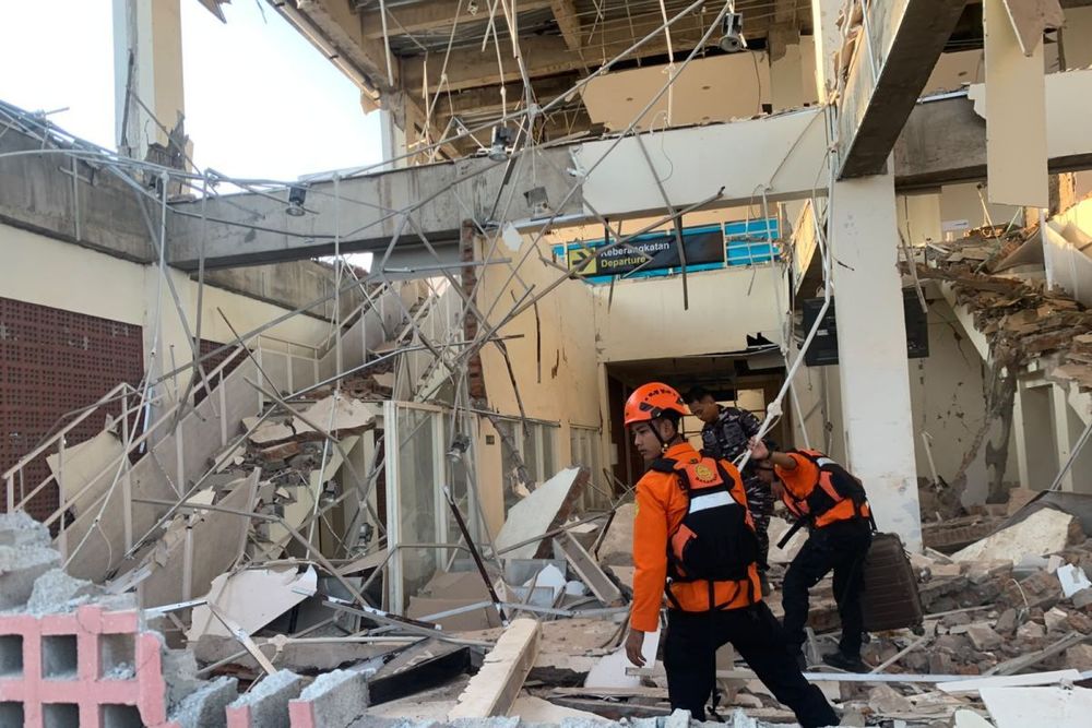
East Nusa Tenggara governor steps up quake response
East Nusa Tenggara Governor Emanuel Melkiades Laka Lena launched a comprehensive emergency response Saturday after a magnitude 7.7 earthquake struck northern Flores, coordinating with district officials to assess damage and mobilize resources across affected areas.
The earthquake struck at a depth of 10 kilometers, with its epicenter located 68 kilometers north-northwest of Ende city and approximately 30 kilometers northeast of Mbay in Nagekeo regency. The tremor triggered more than 230 aftershocks throughout the day, with the strongest measuring magnitude 6.2, complicating rescue operations.
Coordinated Emergency Response
Laka Lena confirmed the provincial government had received multiple reports from district heads and other sources across Flores following the earthquake in Mbay. Officials immediately began coordinating with local leaders to evaluate conditions and organize initial response efforts.
The governor said he coordinated with district heads, deputy heads, and local governments across Flores, which were conducting assessments and checking on residents' conditions in their respective areas.
The provincial government also engaged with the East Nusa Tenggara regional leadership forum, along with multiple ministries and agencies, to secure support for disaster response operations. Laka Lena confirmed coordination with the National Disaster Mitigation Agency chief and ministers from social affairs, health, public works, transportation, state secretary, and basic education portfolios.
Damage Assessment
The earthquake damaged at least 346 houses, including 157 severely damaged, 41 moderately damaged, and 148 slightly damaged. Infrastructure damage also affected 87 educational facilities, 18 health facilities, 5 places of worship, and 6 government offices.
Landslides triggered by the earthquake blocked the Trans-Flores highway and cut off access to Nagekeo, the region closest to the epicenter, hampering rescue efforts and disrupting communications with affected communities.
Tsunami Warning
The earthquake also triggered small tsunamis, with the highest wave reaching 0.94 meters at Maurole-Ende, followed by 0.54 meters at Bulukumba and 0.36 meters at Labuan Bajo. Authorities terminated the tsunami warning at 07:30 WIB on August 15.
Emergency Measures and Aid Distribution
In response to the emergency, the provincial government declared a 14-day emergency response period from August 15 to August 28, 2026, to accelerate rescue operations and aid distribution. President Prabowo Subianto dispatched 50,000 aid packages to affected areas, with distribution hubs established in Labuan Bajo and Maumere to serve six affected districts.
BNPB Chief Suharyanto and a team are expected to travel to Flores on Sunday to support initial response efforts and assist affected communities.
Military and Police Deployment
Police and military units prepared personnel for deployment to support emergency operations. Personnel from the East Nusa Tenggara police, Army's 161/Wira Sakti Regional Military Command, Navy Regional Command VII, and El Tari Air Base were mobilized for deployment to Flores.
Laka Lena confirmed receiving assurances from the police chief, Army regional commander, Navy commander, and air base commander that teams were ready to deploy to affected areas.
Historical Context
The region's vulnerability to seismic activity stems from its location on the Pacific Ring of Fire. The Flores region has experienced 79 earthquakes larger than magnitude 6.0 between 1900 and 2022, with eleven generating tsunamis. A previous magnitude 7.5 earthquake struck the same Flores region in 1992, killing approximately 2,500 people and generating a tsunami up to 26 meters high.